Volcanologist Shane Cronin back from scientific experience of a lifetime
1 June 2022
Professor Shane Cronin’s data from Tonga provides new paradigms and tools for responding to volcanic eruptions.

For the past few months, Professor Shane Cronin has been like a pig in the proverbial, analysing volcanic data on location in Tonga, following the eruption of the Hunga Tonga-Hunga Ha’apai volcano on 15 January.
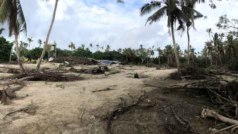
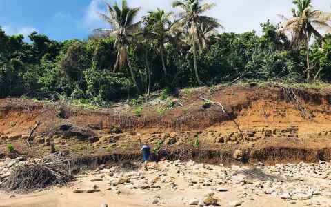
Shane was the first international volcanologist to arrive in the Kingdom of Tonga, after the Hunga eruption and resultant tsunami cleared many islands of any form of habitation. Ash has lain thick on the ground affecting crops, as well as the ocean and marine life. Some airborne ash is still to settle on the seafloor completely.
Shane has been working with Tonga Geological Services (TGS) on the ground, and at sea in research vessels, analysing the geological impact alongside NIWA and others. He has helped strengthen local skills in geological field mapping, deposit description, tsunami surveying and marine ocean-floor survey techniques.
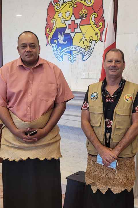
Shane finally returned home to New Zealand on 25 May, with his final job, for now, being to hold a press conference with the Minister of Lands and Natural Resources, Lord Tu’i’afitu, before a briefing with Prime Minister Siaosi Sovaleni.
On the Sunday prior, a church service was delivered by Lord Tu’i’afitu, who said Tonga was grateful to have had the help of the University of Auckland scientist. Shane says he has been impressed by the Tongan people’s response.
“This eruption was a terrifying experience. People are still scared. But what saved lives is that they were responsive. While there were fatalities, and infrastructure and housing damage, the reason it wasn’t worse was because people fled the ocean and made for high ground.”
Adding to the terror was that the eruption also caused the greatest number of lightning strikes ever detected for any natural event in the world.
When I arrived and went to the west, the scenes of damage were apocalyptic. With no resorts, buildings or trees remaining, the coast is now more vulnerable than ever.
Shane and TGS have collected a mountain of new information in Tonga through volcanic ash surveys, impact assessment, tsunami run-up surveys and marine/ocean floor mapping. The data confirms that the explosive energy released from the Hunga submarine volcano was the largest recorded anywhere in the word for more than 140 years. Its plume, at more than 58km, and the spread of the eruption cloud were more than double that of the next largest event on record, the 1991 Pinatubo eruption in the Philippines.
Ash was spread far and wide at a much greater volume than first thought. Shane, TGS and other scientists measured it at more than 130 sites on Tongatapu, Ha’apai and outlying islands. There was also deep ocean sampling of ash and the measurements from both show the eruption was up to five times larger than thought. Ongoing simulations of the ash dispersion will improve new hazard models with collaborating scientists from United States Geological Survey.
Shane and the scientists also measured the flow heights of the tsunami generated by the eruption. The tsunami reached more than 18m along the western Kanokupolu coast and more than 20m on Nomukeiki Island. Many locations had waves exceeding 10m at distances that were more than 85km from the volcano, equivalent to the distance from the Auckland City Campus to just past the Leigh Marine Laboratory. That makes it one of the most widespread and destructive tsunami events known from a volcano.
“When I arrived and went to the west, the scenes of damage were apocalyptic. With no resorts, buildings or trees remaining, the coast is now more vulnerable than ever.”
This was a once in a century eruption on our doorstep. I am so grateful for the opportunity to work so intensively to learn from it.


He says one of the things they discovered was where trees had been planted, they broke the impact of the tsunami, so this could be a simple protective measure for the future.
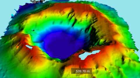
From 17-19 May, a Tongan-based marine survey supported by ENL Ltd (New Zealand) used a WASSP Multibeam mapping system on the MV Pacific Horizon to scan the seafloor on and around the Hunga volcano. It mapped the entire caldera produced by the eruption. The caldera is a deep depression in the top of the volcano, where the centre collapsed inwards on itself after the violent eruption removed the magma. The survey showed the base of the depression is 860m below sea level, and the 4km-wide caldera has filled with an unknown depth of fresh volcanic materials that fell inward.
The islands of Hunga Ha’apai and Hunga Tonga are now less than 25 percent and less than 10 percent of their pre-eruption size, respectively. Around 6.5 cubic kilometres of material has gone from the central volcano compared to when Shane surveyed it last, in late 2015.
With so much of its magma gone, there is now a much lower risk. “There’s still an ongoing source of magma at Hunga, so future activity is inevitable. But I would expect there to be none of this scale for many hundreds of years … the caldera is so deep now that small events won’t have an impact.”
Asked about the ongoing activity, he explains: “The small eruptions still going on are like geysers. Because the caldera is really deep, they won’t cause a problem away from the volcano. We went across them in a boat many times and didn’t even notice them until we saw them on the sonar. They are like a safety valve on a pressure cooker.”
However, he says complacency around volcanic eruptions and tsunami should not set in.
“There are at least ten equally large volcanic centres both north and south of Hunga, including Tofua, Kao, and Fonuelei, along with other major shallow submarine calderas such as Late’iki (Metis Shoal) and Home Reef.”
You have sacrificed your time and energy to undertake this critical role and have transferred your knowledge and skill to our local people.
Shane has provided data to other scientists who have created three tsunami models to help the Kingdom of Tonga with its land-use recommendations in the future.
He says the eruption also opened people’s eyes to how pyroclastic density currents under the sea caused breakages of the submarine cables, and the work that needs to be done to safeguard against these “sideways waves” in the future.
“The eruption has opened our eyes to that problem.”
At the press conference, on Shane’s last day in Tonga, Lord Tu’i’afitu thanked him for his work.
“You have sacrificed your time and energy to undertake this critical role and have transferred your knowledge and skill to our local people.
"This knowledge will stay with us ... and inspire scientific investigation for a safer Tonga.”
Says Shane: “This was a once in a century eruption on our doorstep. I am so grateful for the opportunity to work so intensively to learn from it, alongside such a warm and engaged group of colleagues in Tonga.”
By Denise Montgomery
This story first appeared in UniNews June 2022 edition.