School of Architecture and Planning
Applications for 2025-2026 open on 1 July 2025
Aerodynamic Testing of Ventilation in Airtight Homes - Improving Natural Ventilation through Architectural Design
Project code: ENG002
Supervisor(s):
Discipline(s):
School of Architecture and Planning
Aerodynamics laboratory
Project
BRANZ found that newer, airtight homes often overheat due to insufficient ventilation. We aim to show that natural ventilation, influenced by floor plans and opening placement, can be effective in Auckland homes. This may remove the need for default mechanical systems and help reduce cost and design complexity.
The role
This project aims to use a precise method for measuring airflow in wind tunnel tests and to examine how architectural design, including floor plans and opening placement, affects natural ventilation in small Auckland homes using aerodynamic testing methods.
The expected outcome includes two case studies, one best and one worst design, tested to determine which configurations meet the minimum ventilation rate of 0.35 ACH required for healthy indoor air quality.
Project Objectives
1. Use a precise method to measure airflow in aerodynamic wind tunnel tests.
2. Evaluate how architectural design variables such as floor plans and opening placement influence natural ventilation in small homes, using aerodynamic testing methods.
3. Compare best and worst case designs to evaluate their natural ventilation performance using aerodynamic testing and their ability to meet the 0.35 ACH ventilation benchmark.
Required Skills
Candidates should show strong interest in aerodynamics, natural ventilation, and sustainable building design. A background in or enthusiasm for architectural technology, environmental design, and academic research is essential. Familiarity with design tools, wind tunnel testing, or airflow analysis is a plus.
Current Stage of AI Tools in Architecture and Education
Project code: ENG003
Supervisor(s):
Sarosh Mulla
Ferdinand Oswald
Discipline(s):
School of Architecture and Planning
Project
New AI tools are emerging rapidly, while existing ones continue to evolve at a swift pace. In architecture, AI tools could be used in documentation, quality assurance processes, and compliance with NZS and building code requirements. AI can also play a crucial role in technology-enhanced learning. However, this continuously evolving and expansive landscape makes it difficult to determine which of these tools could serve the architectural profession or the construction industry as a whole.
The role
The goal of this scholarship project is to build on the work initiated last year through a research project, by conducting a survey of currently available AI tools dedicated to the architecture profession. It is essential to understand how AI tools can positively support the architecture profession and tertiary education, as well as to examine their potential disruptive consequences.
This research will be conducted using AI tools and will include a classification of opportunities for AI in architecture, including its application in teaching the discipline.
Objectives
1. Conduct a survey of currently available AI tools for architectural design and architectural technology, building on the results of a previous research project.
2. Evaluate the benefits, potential disruptions, and possibilities for implementing these tools in both education and professional practice.
3. Explore the combined use of these tools as for research and practice.
We are seeking one student to participate in this project. Alessandro Premier is available to provide support and meet with students prior to their submissions. To schedule a meeting, please contact Alessandro via email. This project will be incubated within the Future Cities Research Centre, drawing on the collaborative expertise and support of its diverse members. Results will be presented to the School of Architecture students.
Requirements
Prospective candidates for this project should demonstrate a passion for academic research, an interest in architectural technology, and experience with AI tools.
A Guide to Wairarapa Architecture
Project code: ENG016
Supervisor(s):
Discipline(s):
School of Architecture and Planning
Project
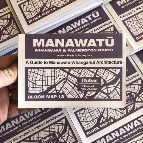
Supported in part by a number of UoA Summer Scholarships, the New Zealand Institute of Architects has published a series of maps of New Zealand architecture. Refer: https://www.andrewbarrielab.com/block
The role
This scholarship project involves the research and production for a map of the Hutt Valley and the Wairarapa region. The project will begin with library-based research to gather information, moving on to the layout and graphic of the map itself, before carrying out fieldwork to verify the correctness and currency of the map produced.
Requirements
Solid research and graphic design skills are a necessity, and the ability to write well about architectural history is an advantage.
Timing
The project will be supervised throughout the summer with weekly meetings. The map will be published (printing sponsored by Dulux) in early-2026 by Architecture New Zealand (the nation’s most significant architecture journal), so the work project will run mid-November to mid-February.
A Guide to North Shore Architecture
Project code: ENG017
Supervisor(s):
Discipline(s):
School of Architecture and Planning
Project
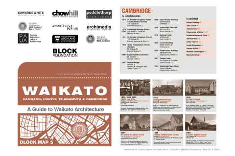
Supported in part by a number of UoA Summer Scholarships, the New Zealand Institute of Architects has published a series of maps of New Zealand architecture. Refer: https://www.andrewbarrielab.com/block
The role
This scholarship project involves the research and production for a map of Devonport, Takapuna, and the North Shore area. The project will begin with library-based research to gather information, moving on to the layout and graphic of the map itself, before carrying out fieldwork to verify the correctness and currency of the map produced.
Requirements
Solid research and graphic design skills are a necessity, and the ability to write well about architectural history is an advantage.
Timing
The project will be supervised throughout the summer with weekly meetings. The map will be published (printing sponsored by Dulux) in mid-2026 by Architecture New Zealand (the nation’s most significant architecture journal), so the work project will run mid-November to mid-February.
Embodied Architectural Intelligence: AI-Driven Spatial Generation and Actuation
Project code: ENG018
Supervisor(s):
Discipline(s):
School of Architecture and Planning
Project
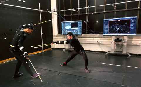
This summer scholarship offers an opportunity to explore new architectural applications of an AI system developed at the arc/sec Lab in collaboration with the Dance Department. Trained on a large dataset of improvisational dance, the AI system has demonstrated its ability to generate dynamic, movement-informed outputs.
The role
The next phase of research focuses on applying this system in different architectural contexts. The Scholarship will look into the generation of three-dimensional spatial drawings and the actuation of responsive architectural structures.
Carving Out New Construction Knowledge
Project code: ENG036
Supervisor(s):
Discipline(s):
School of Architecture and Planning
Project
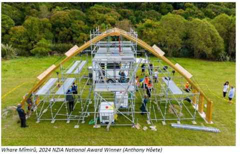
The summer scholar will work on a project that builds upon previous NZIA award-winning Natural Hazards Commission-funded research, Whare Mīmirū. This research designed, built and tested a traditional form of Māori construction for seismic resilience.
The role
The scholar will work with Professor Hōete at the University, but also with industry in the field. Carving Out New Construction Knowledge is research supported by MBIE’s Vision Mātauranga Capability Fund (VMCF).
This research will fabricate three structural elements (curved laminated beams) in the wonderful coastal town of Ōpōtiki, in the Bay of Plenty. This is meaningful research in the sense that it works with living communities (Ngāti Ira o Waioweka and Rāwhiti East Coast Scaffolding), raising Māori capabilities in modern methods of timber fabrication.
Our research starts in the forests of the East Coast. It traces the supply chain of timber construction from a standing tree to a lying laminated beam. We will source three species of tree (pine, kahikatea and tōtara), harvest them with chainsaws and logging trucks, extract them from the forest, mill them, dry, curve, glue and set them before testing to destruction.
Tasks
You, our valuable summer scholar, will help document the entire process through advanced technical drawing and videography.
Ideal student
You should be organised, fun, rigorous, CAD proficient, with a willingness to create and capture stories told by various ‘actors’ from our team. This research goes beyond the laboratory and the library: it is undertaken on the whenua.
The Waka Drawing
Project code: ENG037
Supervisor(s):
Discipline(s):
School of Architecture and Planning

Project
The Waka Drawing is design research into a new form of ingenious indigenous drawing. It transforms architectural drawing here in Aotearoa, New Zealand, and aspires to have an impact on architectural representation worldwide.
The role
Our summer scholar will help map our past drawing endeavours undertaken in the design studio, in Auckland and in Tokyo. To capture this design mātauranga and compile the Waka Drawing firstly, as a Manual, and secondly, as a Journal Article. To be shipped out and disseminated.
This innovative research shifts drawing from the colonising Western gaze of the perspective pioneered by Piero Della Francesca in the 15th Century and more recently colonised by every 21st-century CAD package. Instead, our hero is Tupaia, the Polynesian Navigator, who travelled with Cook and who drew spatial relationships as journeys from memory! Wave goodbye to perspective. Say ‘nau mae , haere mai’ to parallel projection! This is a design studio transformation drawn out large.
So, how large? The Waka Drawing is one of the longest drawings you will ever see. It’s not about the individual drawing, it’s about the: Collective. In 2023 one Waka Drawing was 25m long and involved 84 pairs of hands! Many hands on the deck, you might say. Like an ocean voyaging waka, the Waka Drawing is twin-hulled, propelled and double-sided in orientation. Above and below become liquid positions, the drawing ‘floats’ on the horizon.
The Waka Drawing is crafty and crafted. Recalling Robin Evans' comment that the hand-drawn line suggests something of the action that gives rise to it, the Waka Drawing eschews the computer. Instead, the hand-drawn allows us to embrace tattoo and transdisciplinary engagement with cultural artists. Sketch line work specific to the South Pacific. The Waka Drawing is an exercise in brainstorming and concept-forming. Within a slowly drawn-out period of hours, every line counts. There are no erasers, no deletes. The exercise produces: 100% Content.
Required Skills
1. Likes to Write: can text map and articulate clearly to be understood by others
2. Likes to Visualise and imagine innovative, ingenious, indigenous research
3. Likes to do rigorous, relevant, and fun research
Pēpēha Mapping
Project code: ENG038
Supervisor(s):
Discipline(s):
School of Architecture and Planning
Project
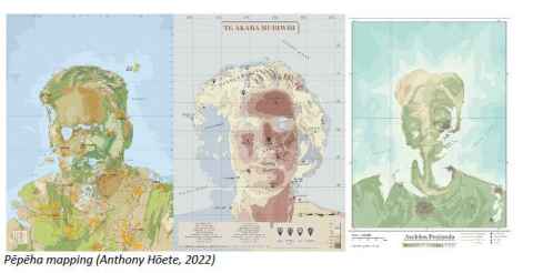
All cultures and communities have their own introductory methods, often reflecting the values, traditions and beliefs most important to them. Iwi mapping was, therefore, an essential oral tradition. The pēpēha is a means of identification for Māori, the indigenous community of Aotearoa, New Zealand, and is renowned for its ability to connect people socio-geologically to the natural world.
As it links individuals to their tribal roots and significant landmarks, it is a forerunner to the Global Positioning System (GPS).
The role
‘Pēpēha Mapping’ is design research being undertaken by Professor Anthony Hōete with the architecture design studios. As a pedagogical exercise, the author-artist creates a spatio-temporal map of their psychogeographic landscape. The traditional features of maunga (mountain), awa (river), and moana (sea) are present. However, today the topography of Pēpēha Mapping is expanded and transcolonised to incorporate contemporary features such as taunga rererangi (airport) and matua (motorway).
Where the Architect/student once produced these maps in the dual role of author-artist, how might someone not versed in drawing practices still be able to participate? What algorithms might be created that nonetheless offer legitimate indigenous practices and authenticity?
Required Skills:
1. Systematic: can write a methodology for others to follow
2. Competent with Adobe Suite(image tracing), INDD and with CAD programmes
3. Likes to Visualise and imagine innovative, ingenious, Indigenous, fun research