Environment
Applications for 2025-2026 open on 1 July 2025
Evaluating the magnet effect in Aotearoa’s ecosystems: are exotic plants good or bad for pollination services?
Project code: SCI042
Supervisor(s):
Sandra Anderson
Discipline(s):
School of Environment
School of Biological Sciences

Project
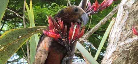
The magnet effect refers to attractive flowering plants drawing in pollinators, which can benefit or distract from neighbouring species.
The role
This project will evaluate the potential for magnet effects in Aotearoa-New Zealand by identifying susceptible native plant species based on their phenology, distribution, and pollinators. We will review global literature to understand the conditions under which magnet effects occur. These insights will help us assess their relevance in New Zealand ecosystems and develop methods for empirical field evaluation.
Geospatial Simulation of Traffic Emissions under Auckland’s Congestion Charging Scheme
Project code: SCI043
Supervisor(s):
Dr Minh Kieu
Discipline(s):
School of Environment
Civil and Environmental Engineering
Project
Auckland is expecting the implementation of a congestion charging scheme in late 2026. This is a pivotal moment for shaping the future of mobility, emissions, and urban health outcomes in the region. While policy scenarios are being considered, few of them have been tested with spatially explicit, data-driven models to evaluate their likely impacts.
From a data analyst’s perspective, a major challenge in Auckland is the unreliable and patchy nature of traffic count data, collected inconsistently across space and time. Busy corridors may be monitored more frequently, while others are counted once every 7-8 years, leading to significant spatial bias.
The role
To overcome this, we aim to build an agent-based model (cellular automata) of traffic emissions in Auckland. As a summer project, we plan to replicate a recent a simulation that focused on Amsterdam.
Skills required
- Strong foundation in data analytics (e.g., with R, Python, or both)
- Prior exposure to or understanding of agent-based models (NetLogo, GAMA, or custom platforms such as in Python)
- Familiarity with geospatial tools (e.g., GeoPandas, QGIS, or sf in R)
Ability to work with large datasets (traffic, emissions, mobility, land use)
Mapping Urban Cleanliness: The Geography of Public Waste Bins in Auckland
Project code: SCI044
Supervisor(s):
Dr Katarzyna Sila-Nowicka
Discipline(s):
School of Environment
Project
Auckland is currently undergoing a reduction in the number of public waste bins due to ongoing financial constraints. While cost-saving measures are necessary, removing bins from urban areas introduces a host of problems. Some examples include increased littering in busy areas, and decreased walkability leading to negative public health and environmental outcomes.
Unfortunately, open data sources such as OpenStreetMap (OSM) do not currently provide a comprehensive or reliable spatial inventory of bin locations and related metadata for Auckland. This presents a significant challenge for researchers and planners who seek to evaluate how such infrastructure changes impact urban life.
The role
This project addresses that gap by developing a crowdsourced dataset of public waste bins, combined with GIS and spatial analysis, to assess their geographic distribution, equity of access, and potential walkability impacts.
Ideal student
Priority will be given to:
- Final-year undergraduate students, preferably majoring in GIScience, Urban Planning, Engineering, or Public Health.
- Exceptionally strong second-year students who have taken GIScience and demonstrated high performance are also encouraged to apply.
- Students intending to use this work as a foundation for an Honours or Master’s thesis will be prioritised.
Skills
Proficiency in GIS software, including ArcGIS, QGIS, and optionally DuckDB.
Paleomagnetic methods for understanding volcanic fields
Project code: SCI045
Supervisor(s):
Discipline(s):
School of Environment
Project
The role involves preparation and analysis of igneous rocks samples for paleomagnetic analyses of dikes and sills of the Hopi Buttes volcanic field.
Ideal student
The student should have a keen interest in Earth Science and laboratory analyses of rock samples.
Mapping Green Space Quality in Tāmaki Makaurau Auckland
Project code: SCI046
Supervisor(s):
Hyesop Shin
Discipline(s):
School of Environment
Project
This project invites students to explore and evaluate green spaces across Tāmaki Makaurau Auckland by collecting and analysing data on park amenities. You’ll build a spatial database of features such as playgrounds, walking tracks, BBQ areas, and more. Using this data, you'll help develop quality metrics to better understand what attracts people to parks – and why.
The role
The project involves field data collection, data curation, and developing an interactive dashboard to visualise parks and their amenities across the city.
Ideal student
Ideal for 3rd-year students in GIScience, Engineering, Urban Planning or Computer Science, though motivated 2nd-year students with relevant skills are also welcome.
Skills gained
You’ll gain experience in applied geospatial analysis, database design, and data visualisation – all while contributing to a project with real-world impact.
Less talk, more action: Co-designing practical focal topics for the SUSTAIN module
Project code: SCI047
Supervisor(s):
Anthony Viennaminovich Gampell
Discipline(s):
School of Environment
Project
This project will inform the learning design refresh for three focal topics taught across the three courses within the SUSTAIN module, moving toward more practical and active citizenship in education for sustainability.
The role
In co-design with the SUSTAIN teaching team, we will shift the focal topics from theory-based toward a more practical learner-centred approach. Therefore bridging the gaps between theory and practical action in response to employability and the graduate profile.
Ideal student
Past/ current SUSTAIN module experience is preferred but not required.
Hyper-explosive Eruptions: Why can small eruptions go hyper?
Project code: SCI048
Supervisor(s):
Discipline(s):
School of Environment
Project
The student will assist in laboratory preparation and physical characterization of fragmented particles (glass) resulting from high-pressure fragmentation experiments and volcanic ash.
The role
Tasks include sieving and laser diffraction grain size analysis, SEM stub and mount preparation, SEM-image acquisition, image processing for particle shape and fracture analysis.
Required skills
Lab experience preferred.
Timing
Dec–Feb. This work supports a broader programme MBIE SI project 3730154, on magma-water interaction and its role in triggering hyper-explosive eruptions.
Visual arts, disaster risk and spatial information: an exploratory dialogue
Project code: SCI049
Supervisor(s):
Discipline(s):
School of Environment
Project
This project explores how visual arts can help facilitate the sharing of spatial information related to disaster risk with local stakeholders. This will be done by developing a piece of visual art sharing spatial information related to disaster risk, and identifying opportunities and challenges associated with this process.
Expected outputs
- Visual art piece for integration into the GIS database for an emergency management group
- 1000-word policy brief
Skills required
- Completion of year two of BSc GISci and BFA
- Completion of GEOG325
A new view through St. Helliers volcano
Project code: SCI050
Supervisor(s):
Jie Wu
Discipline(s):
School of Environment

Project
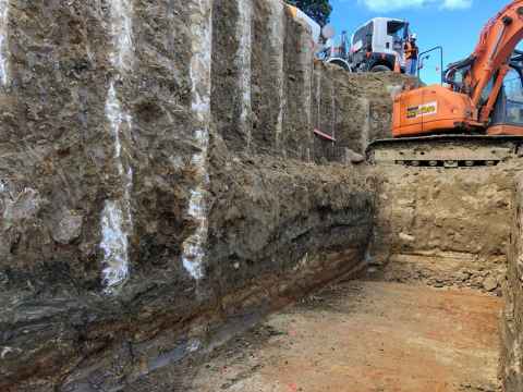
During construction of a new age-care facility, we have been able to collect a new and complete set of samples through a previously undescribed Auckland volcano (St. Helliers).
The role
Using chemical and lithological methods the successful candidate will explore the composition and progression of this little-known eruption.